|
|
|
|
|
|
|
|
State of Idaho Military Division |
|
|
|
CORS -
Survey Grade Reference Station Files - Boise, Idaho |
|
|
|
|
|
|
|
|
|
|
|
|
|
|
|
Site Details: |
|

|
|
|
|
Datum: WGS-84 |
Elevation Mask: 0 |
|
|
|
Latitude: 43 33' 32.64530" N |
Logging Interval: 1s |
|
|
|
Longitude: 116 13' 41.98206" W |
Rollover Period: 1 Hour |
|
|
|
Ground Height HAE: 858.851m |
Antenna Ht: 0.00m |
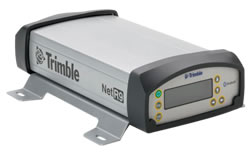
Data Collected with Trimble NetR9
Receiver and a Trimble Zephyr Geodetic Antenna. |
|
|
|
|
|
Site Documentation
|
|
|
|
|
|
|
|
|
|
Available Data Files: |
|
|
|
|
|
|
|
|
|
|
|
Rinex
|
|
Raw (Not Active at This Time)
|
|
|
|
|
|
|
|
|
|
|
|
|
|
|
|
|
|
|
|
|
|
File Naming: |
|
|
|
|
|
Rinex - each file is named using a
5130K77180YYYYMMDDHH00B.12o, n, or g, format. 5130K77180 indicates the
site. YYYY is
the 4-digit year, MM the month, DD the day of the month (local day) and HH is the start
hour of the data file GMT Time (24-hour format). "00" are minute placeholders
(not used). The "B" is local collection identifier. The ".12" is the 2-digit year and the last character
indicates: o=observation data, n=navigation data, g=glonass navigation data.
|
|
|
|
|
|
|
|
|
|
RAW -
(Not Active at this Time) |
|
|
|
|
|
|
|
|
|
Data Storage: |
|
|
|
|
|
Rinex Data Files are normally available online for 120 days, after which they are
deleted. Older data is available only by special request. Users are encouraged
to download data as soon as practicable. |
|
|
|
|
|
|
|
|
|
Raw Data Files
(Not Active at this Time) are available online for 120 days only. No backup files are kept.
|
|
|
|
|
|
|
|
|
|
System Notes: |
|
|
|
|
|
The Base Position was calulated from OPUS using
nine 1 hour files. |
|
|
|
|
|
|
|
|
|
Disclaimer: |
|
|
|
|
|
The Idaho Military Division, Environmental Management Office does not guarantee the availability of data, nor do we warrant the suitability of this data for applications not in our direct control.
|
|
|
|
|
|
|
|
|
|
Comments: |
|
|
|
|
|
If you have any comments please Email them to the Reference Station Administrator
Nathan Bentley
|
|
|
|
|
|
|
|